Coachella Valley
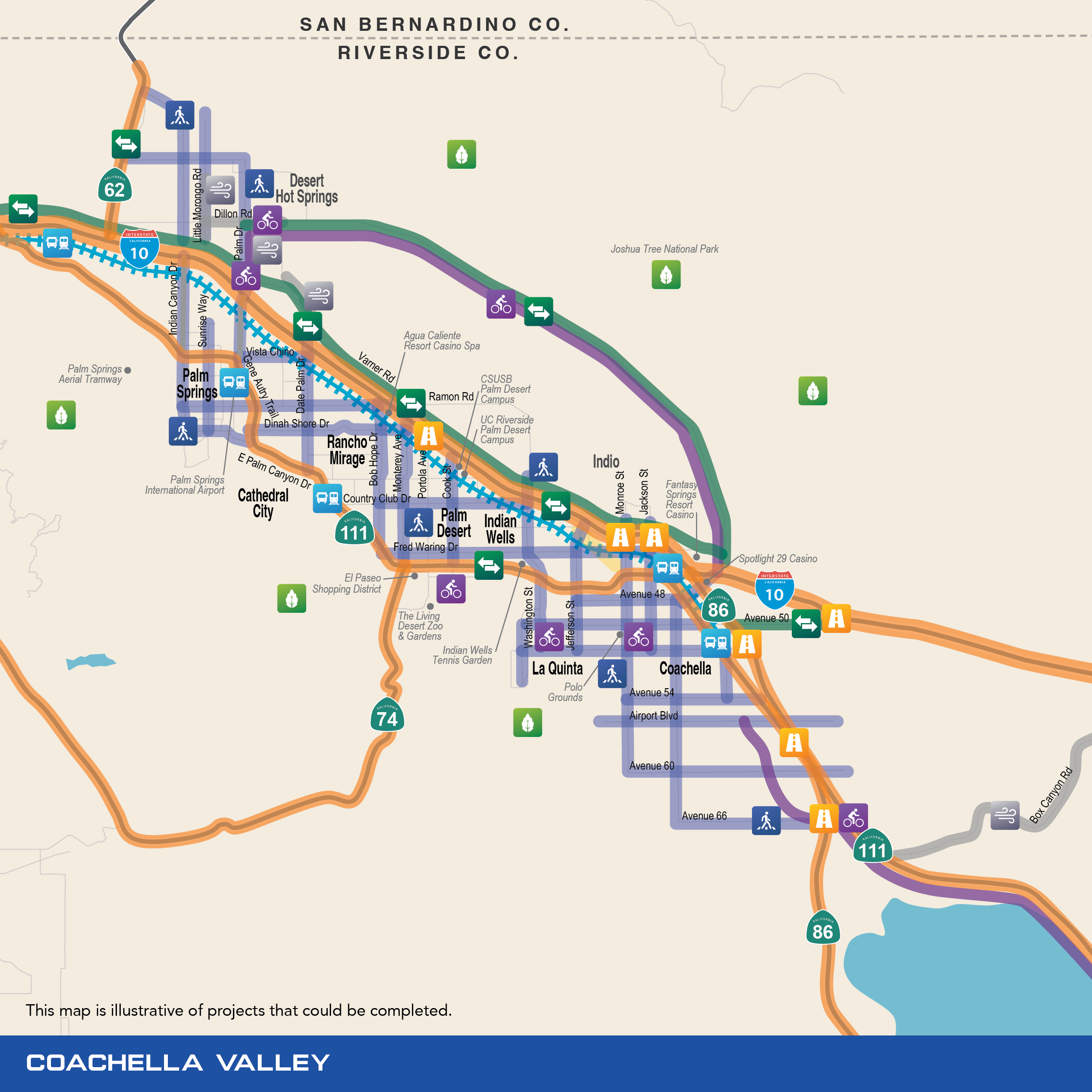
The Coachella Valley has a distinct character and unique transportation challenges, such as floods, blowing sand, and large-scale tourism. Through the TRP, residents in the Coachella Valley can expect mobility improvements in their communities that provide real traffic relief and mobility options as the population continues to grow.
All revenues generated in the Coachella Valley through a future ordinance and expenditure plan will remain in the Coachella Valley. The Coachella Valley Association of Governments (CVAG) will implement projects identified in the Plan in the Coachella Valley. Funding will provide investments for projects in communities that fully participate in, and are compliant with, the Coachella Valley’s Transportation Uniform Mitigation Fee (TUMF) and the procedures approved by the Coachella Valley Conservation Commission for the Coachella Valley Multiple Species Habitat Conservation Plan.
Since 1989, CVAG has been entrusted to manage the regional transportation network. CVAG establishes its priorities according to the Transportation Project Prioritization Study (TPPS), which is a merit-based method of prioritizing all regional projects in the Coachella Valley. The TPPS is updated every few years as the Coachella Valley’s population grows and becomes more diverse in order to address different mobility needs, new technologies, state and federal policy as well as worldwide climate and economic trends.
![]()
Safe Streets & Roads
The TRP will keep roads, highways, and sidewalks safe and smooth throughout Riverside County. The plan includes a range of road and safety improvements, including fixing potholes, upgrading medians and intersections, modernizing traffic signals, and protecting infrastructure from natural hazards.
Examples of road safety and maintenance improvements include:
- I-10
- Highway 111
- Highway 86
- Ramon Road
- Cook Street
- Fred Waring Drive
- Gene Autry Trail/Palm Drive
- Indio Boulevard
- Washington Street
- Monterey Avenue
- Bob Hope Drive
- Dinah Shore Drive
- Date Palm Drive
- Little Morongo Road
- Avenue 50
![]()
Highways
The TRP will reduce traffic congestion by completing freeway projects, improving interchanges and connections, using innovative technologies, adding new lanes, and more.
Examples of highway improvements include:
- Adding Express Lanes on I-10
- Improving connections on:
- I-10
- SR-86
- Highway 111
- Highway 62
- Highway 74
- Grade separations on SR-86, including a new bridge at Avenue 50
- Expand Freeway Service Patrol to I-10 to quickly clear incidents from the freeway and keep traffic flowing
![]()
Regional Connections
The TRP will create new multimodal travel corridors that will relieve congestion, reduce commute time, and provide faster and safer alternatives to today’s limited routes.
Examples of new regional connections include:
- I-10 Bypass
- Extending Avenue 50 between I-10 and SR-86
![]()
Public Transportation
The TRP makes a historic investment in Riverside County’s public transportation system, including by increasing the frequency and safety of trains and buses, building new tracks and stations, and adding new transit and mobility options.
Examples of public transportation improvements include:
- Expanding rail service into the Coachella Valley from Riverside, San Bernardino, Orange, and Los Angeles counties through the CV Rail project
- Introducing new affordable public transportation options for seniors, veterans, students, individuals with disabilities, and disadvantaged communities
- Partnering with Coachella Valley companies to encourage alternative commuting
![]()
Active Transportation
The TRP makes it easier to get around Riverside County, no matter how you choose to move. It includes investments in active transportation infrastructure, including new protected bike lanes, bicycle facilities, and pedestrian safety measures.
Examples of active transportation improvements include:
- Extending the CV Link to:
- North Shore
- Desert Hot Springs
- Expanding the existing active transportation into the design of complete streets
- Creating multi-modal connections, such as improvements along Dillon Road
- Accommodating electric vehicles, such as golf carts and other low-speed electric vehicles, to better serve the mobility and independence among seniors, individuals with disabilities, and unserved communities
![]()
Flood & Blowsand Control
Blowsand and flooding are two natural hazards that can occur in the unique desert environment of the Coachella Valley. The TRP will ensure these hazards don’t derail your commute with resiliency and infrastructure improvement projects.
Examples of flood and blowsand improvements include:
- Building bridges and resilient infrastructure on roads prone to flooding or blowsand issues, such as:
- Indian Canyon
- Gene Autry Trail
- In the Palm Springs, Desert Hot Springs, and Cathedral City areas
- Addressing persistent flooding along Box Canyon Drive
![]()
Environmental Mitigation
Along with improving mobility and transportation throughout Riverside County, the TRP will also ensure that the region’s natural resources and beauty will be preserved, increasing quality of life among residents.
In the Coachella Valley, this includes preserving the Coachella Valley’s natural areas in compliance with the Coachella Valley Multiple Species Habitat Conservation Plan.